


R.E.News future Technology-Bentley Systems and Worldsensing to integrate Topcon GNSS Technology
 17/04/24-FR-English-NL-footer
Bentley Systems et Worldsensing vont intégrer la technologie GNSS Topcon
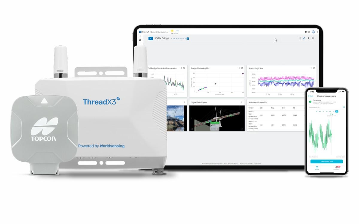 Image- Topcon Positioning Systems
Topcon Positioning Systems a annoncé des accords stratégiques avec Bentley Systems et Worldsensing pour intégrer sa technologie avancée GNSS (Global Navigation Satellite System) dans les logiciels innovants et les solutions de connectivité des entreprises.
« Cette série d'accords est un exemple de l'innovation et de la collaboration qui stimulent l'adoption de technologies dans nos secteurs », a déclaré Ian Stilgoe, vice-président des affaires émergentes chez Topcon. « Non seulement nous améliorons les flux de travail et les gains opérationnels pour les utilisateurs finaux, mais nous étendons également la technologie Topcon GNSS à de nouveaux marchés et cas d'utilisation passionnants.
Systèmes Bentley
Dans le cadre de son accord avec Bentley Systems, une société de logiciels d'ingénierie d'infrastructure leader du secteur dont les solutions sont utilisées par des professionnels et des organisations de toutes tailles, pour la conception, la construction et l'exploitation de routes et de ponts, de chemins de fer et de transports en commun, d'eau et d'eaux usées. , travaux publics et services publics, bâtiments, installations minières et industrielles — Topcon donnera accès à son puissant moteur de traitement GNSS basé sur le Web. Bentley a intégré cette technologie dans sa solution avancée de surveillance iTwin IoT.
« La combinaison de notre expertise en technologie GNSS avec les plates-formes logicielles de classe mondiale de Bentley permettra aux utilisateurs d'exploiter des informations géospatiales précises et en temps réel pour améliorer la prise de décision et l'efficacité opérationnelle », a déclaré Stilgoe.
« Nous sommes ravis d'annoncer cette intégration de la technologie GNSS de Topcon dans notre suite de solutions de surveillance basées sur l'IoT », a déclaré Steve Bentley, directeur principal de l'infrastructure IoT pour Bentley Systems. « Cette intégration permettra à nos utilisateurs de combiner des données de surveillance géospatiales rentables avec le large éventail de données de capteurs géotechniques, environnementaux et structurels que nous prenons déjà en charge – fournissant des informations en temps réel sur les actifs qui peuvent être combinées avec des données d'ingénierie pour faire progresser les infrastructures numériques. jumeaux."
Détection du monde
Pionnier mondial de l'IoT dans les solutions de connectivité pour la surveillance géotechnique, structurelle et environnementale, Worldsensing a intégré le récepteur GNSS Topcon AGM-1 à son produit haut débit Thread X3. Le résultat est un nouveau système de positionnement précis pour surveiller les géorisques tels que les chutes de pierres et les glissements de terrain dans les mines à ciel ouvert, les remblais ferroviaires et autres structures au sol.
"Cela permettra aux professionnels de l'industrie d'identifier de manière proactive les risques potentiels d'affaissement, de soulèvement, de glissement de terrain, de tassement et de prendre des mesures préventives", a déclaré Stilgoe. « Les opérations minières et l’industrie ferroviaire bénéficieront grandement de cette collaboration. Les professionnels de ces domaines peuvent désormais accéder à une solution de surveillance complète qui garantit la sécurité de leurs opérations tout en optimisant la productivité, le tout à un coût bien inférieur à celui d'avant.
Cette intégration marque une étape importante dans la technologie de surveillance des géorisques, offrant une solution de connexion et de collecte qui permet la détection et l'analyse en temps réel des risques potentiels. En tirant parti de la technologie GNSS comme composant principal, Topcon et Worldsensing apportent rentabilité et efficacité aux applications de surveillance des mouvements du sol tout en réduisant l'investissement initial requis pour la surveillance GNSS.
« Cette nouvelle offre vise à relever les défis courants auxquels sont confrontés les déploiements IoT aujourd'hui, à savoir l'accès à des solutions de bout en bout, évolutives et flexibles », a déclaré David Deprez, directeur général de Worldsensing. « Nous facilitons le déploiement massif de l'IoT pour la surveillance GNSS en collaboration avec les principaux fournisseurs de technologies dans le domaine. Les clients reconnaîtront rapidement la valeur de cette offre révolutionnaire.
Disponible pour une utilisation commerciale aux États-Unis, au Canada, en Australie et dans la région EMEA (Europe, Moyen-Orient et Afrique), la solution étendra sa portée à l'Amérique du Sud et à l'Amérique latine.
NJC.© Info Topcon Positioning Systems
-------------------------------------------------------------------------------------------------------------------
17/04/24-English
Bentley Systems and Worldsensing to integrate Topcon GNSS Technology
Image- Topcon Positioning Systems
Topcon Positioning Systems has announced strategic agreements with Bentley Systems and Worldsensing to integrate its advanced GNSS (Global Navigation Satellite System) technology into the companies’ innovative software and connectivity solutions.
“This series of agreements is an example of the innovation and collaboration that is driving technology adoption in our industries,” said Ian Stilgoe, vice president of Emerging Business for Topcon. “Not only are we improving workflows and operational gains for end users, but we are also expanding Topcon GNSS technology into exciting new markets and use cases.”
Bentley Systems
As part of its agreement with Bentley Systems — an industry-leading infrastructure engineering software company whose solutions are used by professionals, and organizations of every size, for the design, construction, and operations of roads and bridges, rail and transit, water and wastewater, public works and utilities, buildings, mining and industrial facilities — Topcon will provide access to its powerful web-based GNSS processing engine. Bentley has integrated this technology into their advanced iTwin IoT monitoring solution.
“Combining our expertise in GNSS technology with Bentley’s world-class software platforms will allow users to leverage accurate and real-time geospatial information for improved decision-making and operational effectiveness,” Stilgoe said.
“We’re excited to announce this integration of Topcon’s GNSS technology into our suite of IoT-based monitoring solutions,” said Steve Bentley, senior director of Infrastructure IoT for Bentley Systems. “This integration will enable our users to combine cost-effective geospatial monitoring data with the wide range of geotechnical, environmental, and structural sensor data that we already support — providing real-time asset intelligence that can be combined with engineering data to advance infrastructure digital twins.”
Worldsensing
A global IoT pioneer in connectivity solutions for geotechnical, structural and environmental monitoring, Worldsensing has integrated the Topcon AGM-1 GNSS receiver with its Thread X3 broadband product. The result is a new Accurate Positioning System to monitor geohazards such as rock falls and landslides in pit mines, rail embankments and other ground structures.
“This will empower industry professionals to proactively identify potential risks of subsidence, heave, landslip, settlement and undertake preventive measures,” Stilgoe said. “Mining operations and the rail industry will greatly benefit from this collaboration. Professionals in these fields can now access a comprehensive monitoring solution that ensures the safety of their operations while optimizing productivity, all at a much lower cost than before.”
This integration marks a significant milestone in geohazard monitoring technology, offering a connect-and-collect solution that enables real-time detection and analysis of potential risks. By leveraging GNSS technology as the core component, Topcon and Worldsensing bring cost-effectiveness and efficiency to ground-movements monitoring applications while reducing the initial investment required for GNSS monitoring.
“This new offering aims to address the common challenges facing IoT deployments today, namely access to end-to-end, scalable, and flexible solutions,” said David Deprez, managing director of Worldsensing. “We are facilitating IoT mass deployment for GNSS monitoring in collaboration with leading technology providers in the field. Customers will quickly recognize the value of this game-changing offer.”
Available for commercial use in the United States, Canada, Australia, and EMEA (Europe, Middle East, and Africa), the solution will expand its reach to South and Latin America.
NJC.© Info Topcon Positioning Systems
------------------------------------------------------------------------------------------------------------------
17/04/24-NL
Bentley Systems en Worldsensing gaan Topcon GNSS-technologie integreren
Image- Topcon Positioning Systems
Topcon Positioning Systems heeft strategische overeenkomsten aangekondigd met Bentley Systems en Worldsensing om zijn geavanceerde GNSS-technologie (Global Navigation Satellite System) te integreren in de innovatieve software- en connectiviteitsoplossingen van de bedrijven.
“Deze reeks overeenkomsten is een voorbeeld van de innovatie en samenwerking die de adoptie van technologie in onze sectoren stimuleren”, zegt Ian Stilgoe, vice-president van Emerging Business bij Topcon. “We verbeteren niet alleen de workflows en operationele voordelen voor eindgebruikers, maar we breiden ook de Topcon GNSS-technologie uit naar opwindende nieuwe markten en gebruiksscenario’s.”
Bentley-systemen
Als onderdeel van de overeenkomst met Bentley Systems, een toonaangevend softwarebedrijf voor infrastructuurtechniek wiens oplossingen worden gebruikt door professionals en organisaties van elke omvang, voor het ontwerp, de aanleg en de exploitatie van wegen en bruggen, spoorwegen en openbaar vervoer, water en afvalwater , openbare werken en nutsvoorzieningen, gebouwen, mijnbouw en industriële faciliteiten – Topcon zal toegang bieden tot zijn krachtige webgebaseerde GNSS-verwerkingsengine. Bentley heeft deze technologie geïntegreerd in hun geavanceerde iTwin IoT-monitoringoplossing.
“Door onze expertise op het gebied van GNSS-technologie te combineren met Bentley’s softwareplatforms van wereldklasse kunnen gebruikers nauwkeurige en realtime georuimtelijke informatie gebruiken voor verbeterde besluitvorming en operationele effectiviteit”, aldus Stilgoe.
“We zijn verheugd deze integratie van Topcon’s GNSS-technologie in ons pakket IoT-gebaseerde monitoringoplossingen aan te kondigen”, aldus Steve Bentley, senior director Infrastructure IoT voor Bentley Systems. “Deze integratie zal onze gebruikers in staat stellen om kosteneffectieve geospatiale monitoringgegevens te combineren met het brede scala aan geotechnische, ecologische en structurele sensorgegevens die we al ondersteunen – waardoor realtime asset intelligence wordt geboden die kan worden gecombineerd met technische gegevens om de digitale infrastructuur vooruit te helpen. Tweelingen."
Wereldzin
Worldsensing, een wereldwijde IoT-pionier op het gebied van connectiviteitsoplossingen voor geotechnische, structurele en omgevingsmonitoring, heeft de Topcon AGM-1 GNSS-ontvanger geïntegreerd met zijn Thread X3-breedbandproduct. Het resultaat is een nieuw Accurate Positioning System om georisico's te monitoren, zoals vallende rotsen en aardverschuivingen in mijnen, spoordijken en andere grondconstructies.
“Dit zal professionals uit de industrie in staat stellen om proactief potentiële risico’s van verzakking, deining, aardverschuiving, nederzettingen te identificeren en preventieve maatregelen te nemen”, aldus Stilgoe. “Mijnbouwactiviteiten en de spoorwegindustrie zullen enorm profiteren van deze samenwerking. Professionals op deze gebieden hebben nu toegang tot een uitgebreide monitoringoplossing die de veiligheid van hun activiteiten garandeert en tegelijkertijd de productiviteit optimaliseert, en dat alles tegen veel lagere kosten dan voorheen.”
Deze integratie markeert een belangrijke mijlpaal in de monitoringtechnologie voor geologische gevaren en biedt een connect-and-collect-oplossing die realtime detectie en analyse van potentiële risico's mogelijk maakt. Door gebruik te maken van GNSS-technologie als kerncomponent, zorgen Topcon en Worldsensing voor kosteneffectiviteit en efficiëntie bij het monitoren van grondbewegingen, terwijl de initiële investering die nodig is voor GNSS-monitoring wordt verminderd.
“Dit nieuwe aanbod is bedoeld om de gemeenschappelijke uitdagingen aan te pakken waarmee IoT-implementaties vandaag de dag worden geconfronteerd, namelijk toegang tot end-to-end, schaalbare en flexibele oplossingen”, zegt David Deprez, algemeen directeur van Worldsensing. “We faciliteren de massale inzet van IoT voor GNSS-monitoring in samenwerking met toonaangevende technologieleveranciers in het veld. Klanten zullen snel de waarde van dit baanbrekende aanbod inzien.”
De oplossing is beschikbaar voor commercieel gebruik in de Verenigde Staten, Canada, Australië en EMEA (Europa, Midden-Oosten en Afrika) en zal zijn bereik uitbreiden naar Zuid- en Latijns-Amerika.
NJC.© Info Topcon Positioning Systems
----------------------------------------------------------------------------------------------------------------
Date de dernière mise à jour : 16/04/2024