


R.E.News future Technology-Emesent launches an all-in-one LiDAR, RTK and 360-degree imagery scanner
 06/05/26-FR-English-NL-footer
GX1 : le scanner qui réconcilie vitesse et précision
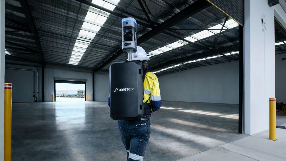 Image-LiDAR, RTK
Dans un secteur où chaque millimètre compte et où le temps est une ressource aussi précieuse que les données collectées, Emesent frappe fort avec une innovation qui pourrait bien redéfinir les standards du relevé topographique. Son nouveau GX1 n’est pas simplement un outil de plus : c’est une promesse — celle de ne plus avoir à choisir entre rapidité et précision.
Au cœur de cette révolution, une fusion technologique élégante. Le GX1 associe LiDAR, RTK, caméras 360° et logiciels intelligents dans un seul et même système parfaitement intégré. Résultat : une précision globale de l’ordre de 5 à 10 millimètres, tout en réduisant jusqu’à 95 % le temps de relevé. Ce qui nécessitait autrefois des semaines peut désormais être accompli en une journée.
Mais l’innovation va plus loin. En s’appuyant sur la technologie SLAM — éprouvée dans des environnements extrêmes, des tunnels sans GPS aux sites industriels complexes — le GX1 démocratise des capacités jusqu’ici réservées à des usages spécialisés. Il transforme le quotidien des géomètres en leur offrant une solution mobile capable de capturer des données fiables, partout et sans compromis.
Pour Stefan Hrabar, cofondateur et directeur de la stratégie, l’ambition est claire :
« Avec le GX1, nous mettons fin au dilemme entre vitesse et précision. Nous donnons aux professionnels les moyens de travailler plus vite, sans jamais sacrifier la qualité des données. »
Pensé pour s’adapter à tous les terrains, le GX1 se décline en quatre modes d’utilisation : sac à dos, perche topographique, montage sur véhicule ou utilisation à la main. Une flexibilité qui ouvre la voie à de multiples applications — relevés routiers, modélisation BIM, suivi de chantier — tout en restant accessible, même pour les opérateurs les moins expérimentés.
Autre atout majeur : sa capacité de géoréférencement flexible. Que ce soit en temps réel via RTK ou en post-traitement avec des points de contrôle, le GX1 réduit considérablement le risque de devoir retourner sur site — un gain de temps et de coûts décisif.
Dans un monde où les infrastructures se complexifient et où les délais se resserrent, le GX1 s’impose comme un allié stratégique. Plus qu’un scanner, c’est un accélérateur de projets — et peut-être, déjà, un nouveau standard pour toute une industrie.
NJC.© Info LiDAR, RTK Stefan Hrabar
--------------------------------------------------------------------------------------------------------------
06/05/26-English
GX1: The Scanner That Reconciles Speed and Precision
Image-LiDAR, RTK
In an industry where every millimeter counts and time is as precious a resource as the data collected, Emesent is making a bold move with an innovation that could well redefine the standards of topographic surveying. Its new GX1 is not simply another tool: it's a promise—the promise of no longer having to choose between speed and precision.
At the heart of this revolution lies an elegant technological fusion. The GX1 combines LiDAR, RTK, 360° cameras, and intelligent software in a single, perfectly integrated system. The result: overall accuracy of 5 to 10 millimeters, while reducing survey time by up to 95%. What once took weeks can now be accomplished in a single day.
But the innovation goes even further. Leveraging SLAM technology—proven in extreme environments, from tunnels without GPS to complex industrial sites—the GX1 democratizes capabilities previously reserved for specialized uses. It transforms the daily work of surveyors by offering them a mobile solution capable of capturing reliable data, anywhere, without compromise.
For Stefan Hrabar, co-founder and Chief Strategy Officer, the ambition is clear:
“With the GX1, we are putting an end to the dilemma between speed and accuracy. We are empowering professionals to work faster, without ever sacrificing data quality.”
Designed to adapt to all terrains, the GX1 comes in four modes of use: backpack, survey pole, vehicle mount, or handheld. This flexibility opens the door to a multitude of applications—road surveys, BIM modeling, construction site monitoring—while remaining accessible, even for the least experienced operators.
Another major advantage: its flexible georeferencing capability. Whether in real time via RTK or in post-processing with checkpoints, the GX1 significantly reduces the risk of having to return to the site—a decisive saving in time and cost.
In a world of increasingly complex infrastructures and tighter deadlines, the GX1 is emerging as a strategic ally. More than just a scanner, it's a project accelerator—and perhaps already a new standard for an entire industry.
NJC.© Info LiDAR, RTK Stefan Hrabar
--------------------------------------------------------------------------------------------------------------
06/05/26-NL
GX1: De scanner die snelheid en precisie combineert
Image-LiDAR, RTK
In een industrie waar elke millimeter telt en tijd net zo kostbaar is als de verzamelde data, zet Emesent een gedurfde stap met een innovatie die de normen voor topografische landmeting wel eens zou kunnen herdefiniëren. De nieuwe GX1 is niet zomaar een nieuw instrument: het is een belofte – de belofte dat u niet langer hoeft te kiezen tussen snelheid en precisie.
De kern van deze revolutie wordt gevormd door een elegante technologische fusie. De GX1 combineert LiDAR, RTK, 360°-camera's en intelligente software in één perfect geïntegreerd systeem. Het resultaat: een algehele nauwkeurigheid van 5 tot 10 millimeter, terwijl de meettijd tot wel 95% wordt verkort. Wat voorheen weken duurde, kan nu in één dag worden gedaan.
Maar de innovatie gaat nog verder. Door gebruik te maken van SLAM-technologie – bewezen in extreme omstandigheden, van tunnels zonder GPS tot complexe industriële locaties – maakt de GX1 mogelijkheden toegankelijk voor iedereen die voorheen alleen voor specialisten beschikbaar waren. Het transformeert het dagelijkse werk van landmeters door hen een mobiele oplossing te bieden waarmee overal betrouwbare gegevens kunnen worden vastgelegd, zonder compromissen.
Voor Stefan Hrabar, medeoprichter en Chief Strategy Officer, is de ambitie duidelijk:
“Met de GX1 maken we een einde aan het dilemma tussen snelheid en nauwkeurigheid. We stellen professionals in staat sneller te werken, zonder ooit in te leveren op datakwaliteit.”
De GX1 is ontworpen om zich aan te passen aan alle terreinen en is verkrijgbaar in vier gebruikswijzen: rugzak, meetstok, voertuigmontage of handheld. Deze flexibiliteit opent de deur naar een veelheid aan toepassingen – wegmetingen, BIM-modellering, monitoring van bouwplaatsen – en blijft toegankelijk, zelfs voor de minst ervaren gebruikers.
Een ander groot voordeel: de flexibele georeferentiemogelijkheid. Of het nu in realtime via RTK is of in de nabewerking met controlepunten, de GX1 verkleint de kans aanzienlijk dat er terug naar de locatie moet worden gegaan – een doorslaggevende besparing in tijd en kosten.
In een wereld van steeds complexere infrastructuren en steeds kortere deadlines ontpopt de GX1 zich als een strategische bondgenoot. Het is meer dan alleen een scanner; het is een projectversneller – en misschien wel nu al een nieuwe standaard voor een hele industrie.
NJC.© Info LiDAR, RTK Stefan Hrabar
------------------------------------------------------------------------------------------------------------------
Date de dernière mise à jour : 05/05/2026