


R.E.News future Technology-From Trenches to Digital Twins as Field Reality Capture Enters the Enterprise GIS
 20/02/26-FR-English-NL-footer
Des tranchées aux jumeaux numériques : quand la réalité du terrain entre dans le SIG d’entreprise
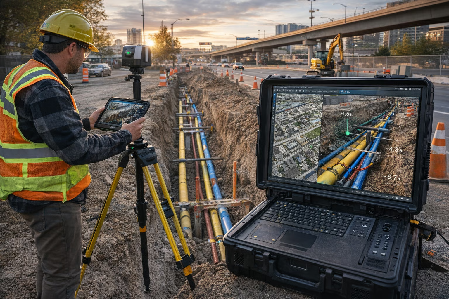 Image-R.E.News©
Dans le secteur mondial des infrastructures, les problèmes les plus coûteux sont souvent invisibles. Canalisations posées il y a trente ans, plans inexacts, archives éparpillées entre papier, fichiers CAD et bases de données fragmentées : chaque ouverture de tranchée devient un pari risqué. Retards, reprises de travaux, incidents de sécurité… le sous-sol mal documenté pèse des milliards chaque année.
Face à cet enjeu, la numérisation des réseaux enterrés n’est plus un simple progrès technique. Elle devient une stratégie de gestion du risque.
Du chantier au système central, sans rupture
Longtemps, produire des relevés « as-built » précis exigeait des équipes spécialisées, des scanners lourds et des semaines de traitement. Les tranchées étaient souvent refermées avant même que les données n’atteignent les systèmes centraux.
Aujourd’hui, un nouveau flux de travail change la donne : la capture terrain s’intègre directement dans les environnements SIG d’entreprise. Concrètement, des équipes utilisent l’application mobile PIX4Dcatch, associée à des dispositifs de positionnement RTK, pour transformer un smartphone ou une tablette en scanner géoréférencé de précision.
Les modèles produits ne restent plus des fichiers isolés : ils sont publiés dans ArcGIS Online et intégrés aux géodatabases organisationnelles. Le chantier devient alors une source d’intelligence géospatiale en temps réel.
De l’image à la donnée exploitable
La différence est majeure. Beaucoup d’organisations possèdent déjà des photos et des scans. Mais tant que ces données restent passives, elles ne servent qu’à documenter.
Intégrées dans une géodatabase structurée, elles deviennent fonctionnelles :
interrogeables,
analysables,
exploitables pour la maintenance, la planification ou la gestion des permis.
La géométrie capturée ne sert plus uniquement de preuve visuelle : elle devient la référence officielle.
Vérifier avant de refermer
L’un des apports les plus décisifs réside dans la vérification en réalité augmentée avant la fermeture des tranchées.
Hier, les écarts entre conception et exécution apparaissaient des mois plus tard — au prix de nouvelles excavations et de litiges contractuels.
Désormais, les équipes peuvent comparer en temps réel le modèle capturé avec les plans de conception. Une canalisation décalée de quelques centimètres ? La correction se fait immédiatement, tant que les engins sont encore sur place.
La validation ne se fait plus après coup. Elle devient un contrôle qualité intégré au chantier.
Le socle des jumeaux numériques
Aucun jumeau numérique crédible ne peut exister sans géométrie fiable. En injectant des modèles validés dans le SIG d’entreprise, les organisations ne créent pas une simple archive 3D : elles posent les fondations d’un jumeau évolutif, mis à jour au fil des interventions.
Le SIG cesse d’être un outil de planification pour devenir l’ossature opérationnelle de l’infrastructure :
inspection virtuelle avant excavation,
analyse de capacité réseau,
compréhension des risques en cas d’incident.
Un changement culturel autant que technologique
La photogrammétrie, le RTK et les plateformes SIG existaient déjà. La rupture ne tient pas à l’invention d’une nouvelle technologie, mais à leur intégration fluide dans le quotidien des chantiers.
La capture mobile démocratise le relevé. Ce qui nécessitait hier des spécialistes peut désormais être réalisé par des équipes formées sur site. Moins d’attente, moins de mobilisation, moins de coûts indirects.
Pour les entrepreneurs, cela signifie une documentation contractuelle solide.
Pour les exploitants, une mémoire d’actifs fiable sur plusieurs décennies.
Pour les assureurs et financeurs, une gouvernance démontrable.
Quand la tranchée devient le point d’entrée du cycle numérique
La transformation est subtile mais profonde. Documenter la réalité ne se fait plus à la fin du chantier. Cela devient une activité continue, intégrée au rythme quotidien des travaux.
La tranchée n’est plus seulement une excavation temporaire.
Elle devient l’instant précis où l’infrastructure physique entre dans sa vie numérique.
NJC.© Info
----------------------------------------------------------------------------------------------------------------
20/02/26-English
From Trenches to Digital Twins: When Field Reality Enters Enterprise GIS
Image-R.E.News©
In the global infrastructure sector, the most costly problems are often invisible. Pipes laid thirty years ago, inaccurate plans, archives scattered across paper, CAD files, and fragmented databases: every trench excavation becomes a risky gamble. Delays, work rework, safety incidents… poorly documented subsoil costs billions every year.
Faced with this challenge, digitizing underground networks is no longer just a technological advancement. It is becoming a risk management strategy.
From Construction Site to Central System, Seamlessly
For a long time, producing accurate "as-built" surveys required specialized teams, heavy-duty scanners, and weeks of processing. Trenches were often backfilled before the data even reached central systems.
Today, a new workflow is changing the game: field capture is being directly integrated into enterprise GIS environments. In practice, teams use the PIX4Dcatch mobile application, combined with RTK positioning devices, to transform a smartphone or tablet into a precise georeferenced scanner.
The resulting models are no longer isolated files: they are published in ArcGIS Online and integrated into organizational geodatabases. The construction site then becomes a source of real-time geospatial intelligence.
From Image to Actionable Data
The difference is significant. Many organizations already possess photos and scans. But as long as this data remains passive, it serves only as documentation.
Integrated into a structured geodatabase, it becomes functional:
queryable,
analyzable,
usable for maintenance, planning, or permit management.
The captured geometry no longer serves solely as visual evidence: it becomes the official reference.
Check before closing
One of the most decisive contributions lies in augmented reality verification before trench closure.
Previously, discrepancies between design and execution would only appear months later—at the cost of further excavations and contractual disputes.
Now, teams can compare the captured model with the design plans in real time. A pipe offset by a few centimeters? The correction is made immediately, while the equipment is still on site.
Validation is no longer done after the fact. It becomes an integrated quality control process on the construction site.
The foundation of digital twins
No credible digital twin can exist without reliable geometry. By injecting validated models into the enterprise GIS, organizations are not simply creating a 3D archive: they are laying the foundations for an evolving twin, updated with each intervention.
GIS is ceasing to be a planning tool and becoming the operational backbone of the infrastructure:
virtual inspection before excavation,
network capacity analysis,
understanding risks in the event of an incident.
A cultural as well as a technological shift
Photogrammetry, RTK, and GIS platforms already existed. The breakthrough lies not in the invention of a new technology, but in their seamless integration into the daily operations of construction sites.
Mobile capture democratizes surveying. What yesterday required specialists can now be carried out by teams trained on-site. Less waiting, less mobilization, fewer indirect costs.
For contractors, this means robust contractual documentation.
For operators, reliable asset records spanning decades.
For insurers and financiers, demonstrable governance.
When the trench becomes the entry point of the digital cycle
The transformation is subtle but profound. Documenting reality is no longer done at the end of the construction project. This becomes an ongoing activity, integrated into the daily rhythm of the work.
The trench is no longer just a temporary excavation.
It becomes the precise moment when the physical infrastructure enters its digital life.
NJC.© Info
----------------------------------------------------------------------------------------------------------------
20/02/26-NL
Van sleuven naar digitale tweelingen: wanneer de realiteit van het veld de bedrijfs-GIS binnenkomt
Image-R.E.News©
In de wereldwijde infrastructuursector zijn de meest kostbare problemen vaak onzichtbaar. Leidingen die dertig jaar geleden zijn aangelegd, onnauwkeurige plannen, archieven verspreid over papier, CAD-bestanden en gefragmenteerde databases: elke sleufgraving wordt een riskante gok. Vertragingen, herwerk, veiligheidsincidenten... slecht gedocumenteerde ondergrond kost jaarlijks miljarden.
Geconfronteerd met deze uitdaging is het digitaliseren van ondergrondse netwerken niet langer slechts een technologische vooruitgang. Het wordt een strategie voor risicobeheer.
Van bouwplaats naar centraal systeem, naadloos
Lange tijd vereiste het produceren van nauwkeurige 'as-built'-metingen gespecialiseerde teams, zware scanners en wekenlange verwerking. Sleuven werden vaak alweer dichtgegooid voordat de gegevens de centrale systemen bereikten.
Tegenwoordig verandert een nieuwe workflow de spelregels: veldmetingen worden direct geïntegreerd in bedrijfs-GIS-omgevingen. In de praktijk gebruiken teams de mobiele applicatie PIX4Dcatch, in combinatie met RTK-positioneringsapparaten, om een smartphone of tablet om te toveren tot een nauwkeurige, georeferentieerde scanner.
De resulterende modellen zijn niet langer geïsoleerde bestanden: ze worden gepubliceerd in ArcGIS Online en geïntegreerd in geodatabases van de organisatie. De bouwplaats wordt zo een bron van realtime geospatiale informatie.
Van beeld naar bruikbare data
Het verschil is aanzienlijk. Veel organisaties beschikken al over foto's en scans. Maar zolang deze data passief blijft, dient het slechts als documentatie.
Geïntegreerd in een gestructureerde geodatabase wordt het functioneel:
opvraagbaar,
analyseerbaar,
bruikbaar voor onderhoud, planning of vergunningsbeheer.
De vastgelegde geometrie dient niet langer alleen als visueel bewijs: het wordt de officiële referentie.
Controleer vóór de afsluiting
Een van de belangrijkste bijdragen is de verificatie met augmented reality vóór de afsluiting van de sleuf.
Voorheen kwamen discrepanties tussen ontwerp en uitvoering pas maanden later aan het licht – met als gevolg extra graafwerkzaamheden en contractuele geschillen.
Teams kunnen het vastgelegde model nu in realtime vergelijken met de ontwerptekeningen. Een leiding een paar centimeter verschoven? De correctie wordt direct uitgevoerd, terwijl de apparatuur nog op de bouwplaats is.
Validatie vindt niet langer achteraf plaats. Het wordt een geïntegreerd kwaliteitscontroleproces op de bouwplaats.
De basis van digitale tweelingen
Een geloofwaardige digitale tweeling kan niet bestaan zonder betrouwbare geometrie. Door gevalideerde modellen in het bedrijfs-GIS te integreren, creëren organisaties niet zomaar een 3D-archief: ze leggen de basis voor een evoluerende tweeling, die bij elke interventie wordt bijgewerkt.
GIS is niet langer alleen een planningstool, maar wordt de operationele ruggengraat van de infrastructuur:
virtuele inspectie vóór de graafwerkzaamheden,
netwerkcapaciteitsanalyse,
inzicht in risico's bij een incident.
Een culturele én technologische verschuiving
Fotogrammetrie, RTK en GIS-platformen bestonden al. De doorbraak zit niet in de uitvinding van een nieuwe technologie, maar in de naadloze integratie ervan in de dagelijkse werkzaamheden op bouwplaatsen.
Mobiele opnames democratiseren landmeten. Wat vroeger specialisten vereiste, kan nu worden uitgevoerd door teams die ter plaatse zijn opgeleid. Minder wachttijd, minder mobilisatie, lagere indirecte kosten.
Voor aannemers betekent dit een solide contractuele documentatie.
Voor beheerders: betrouwbare gegevens over activa die tientallen jaren meegaan.
Voor verzekeraars en financiers: aantoonbaar beheer.
Wanneer de sleuf het startpunt wordt van de digitale cyclus
De transformatie is subtiel maar ingrijpend. Het vastleggen van de realiteit gebeurt niet langer aan het einde van het bouwproject. Het wordt een doorlopende activiteit, geïntegreerd in het dagelijkse werkritme.
De sleuf is niet langer slechts een tijdelijke opgraving.
Het wordt het precieze moment waarop de fysieke infrastructuur haar digitale leven ingaat.
NJC.© Info
-----------------------------------------------------------------------------------------------------------------
Date de dernière mise à jour : 19/02/2026