


R.E.News future Technology- Scheimpflug Imaging Reimagined for Next Generation Infrastructure Sensing
 21/05/26-FR-English-NL-footer
Longtemps cantonné au monde de la photographie aérienne et des applications optiques spécialisées, le principe de Scheimpflug connaît aujourd’hui une renaissance spectaculaire dans le secteur des infrastructures intelligentes.
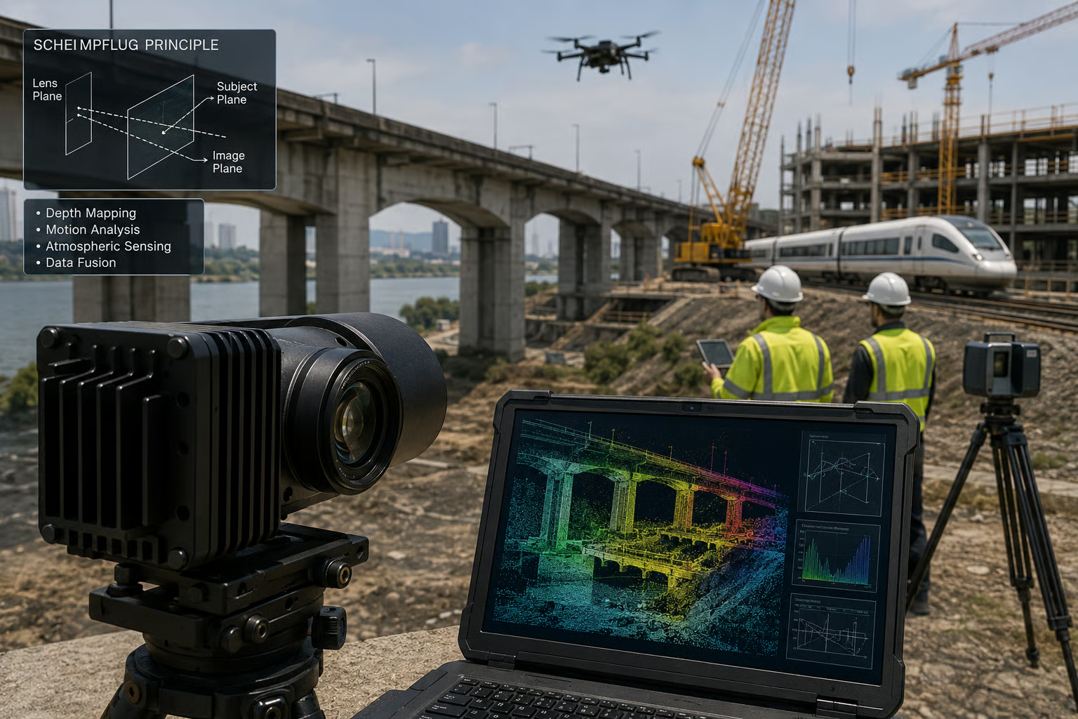 Image-RE.News©
À Georgia Tech Research Institute, des chercheurs transforment cette théorie centenaire en une nouvelle génération de technologie de détection capable de rivaliser avec certains systèmes LiDAR dans les domaines de la construction, du transport et de la surveillance environnementale.
Au cœur de cette innovation se trouve une approche radicalement différente de la mesure spatiale. Contrairement aux systèmes LiDAR traditionnels, qui reposent sur l’émission d’impulsions laser, la technologie Scheimpflug exploite les relations géométriques entre l’objectif, le capteur et l’image pour extraire profondeur, mouvement et données atmosphériques à partir de simples caméras.
Cette évolution ouvre de nouvelles perspectives pour les infrastructures modernes, où les besoins en collecte de données rapides, économiques et riches en informations ne cessent de croître. Grâce à des composants d’imagerie plus accessibles et à des traitements computationnels avancés, ces systèmes promettent une alternative plus flexible et potentiellement moins coûteuse que les solutions laser conventionnelles.
Les travaux menés par le GTRI portent notamment sur le développement de caméras télémétriques, l’intégration de capteurs avancés et les techniques de fusion de données capables d’associer imagerie passive et technologies actives comme le LiDAR. L’objectif n’est pas nécessairement de remplacer les systèmes existants, mais de créer un nouvel écosystème de détection hybride, plus robuste et plus intelligent.
L’un des grands atouts de l’imagerie Scheimpflug réside dans la richesse des données capturées. Là où le LiDAR génère principalement des nuages de points, les systèmes basés sur caméra fournissent des informations visuelles continues pouvant être analysées simultanément pour la profondeur, les anomalies structurelles, les mouvements ou encore les perturbations atmosphériques.
Dans le secteur des infrastructures, les applications sont nombreuses : cartographie de chantiers, inspection de ponts et routes, surveillance des couloirs ferroviaires, gestion des drones ou encore analyse des conditions environnementales. La technologie pourrait également jouer un rôle clé dans le développement des jumeaux numériques, en alimentant les modèles virtuels avec des flux de données en temps réel.
Autre avantage stratégique : sa capacité à fonctionner de manière passive grâce à la lumière ambiante, réduisant considérablement les besoins énergétiques par rapport aux systèmes laser intensifs. Une caractéristique particulièrement intéressante pour les infrastructures connectées et les projets à grande échelle.
Les chercheurs travaillent également sur la fusion intelligente des données afin d’améliorer la précision et la résilience des systèmes dans des environnements complexes tels que le brouillard, la poussière ou les variations lumineuses — des conditions souvent critiques pour les infrastructures de transport et les applications autonomes.
Présentés lors du SPIE Defense + Commercial Sensing Conference, ces travaux suscitent déjà un intérêt croissant dans les secteurs de la défense, de l’ingénierie et des infrastructures intelligentes. Portée par les avancées en vision artificielle et en intelligence computationnelle, l’imagerie Scheimpflug pourrait ainsi devenir l’une des briques technologiques majeures de la prochaine génération de systèmes de surveillance et de gestion des infrastructures.
À l’heure où les opérateurs cherchent des solutions plus accessibles, évolutives et riches en données pour gérer des infrastructures vieillissantes et des environnements de plus en plus complexes, cette technologie redonne vie à un principe optique vieux de plus d’un siècle… avec une ambition résolument tournée vers l’avenir.
NJC. © Info Georgia Tech Research Institute
-------------------------------------------------------------------------------------------------------------------
21/05/26-English
Long confined to the world of aerial photography and specialized optical applications, the Scheimpflug principle is now experiencing a spectacular revival in the smart infrastructure sector.
Image-RE.News©
At Georgia Tech Research Institute, researchers are transforming this century-old theory into a new generation of sensing technology capable of competing with some LiDAR systems in the fields of construction, transportation, and environmental monitoring.
At the heart of this innovation lies a radically different approach to spatial measurement. Unlike traditional LiDAR systems, which rely on the emission of laser pulses, Scheimpflug technology exploits the geometric relationships between the lens, the sensor, and the image to extract depth, motion, and atmospheric data from simple cameras.
This development opens up new possibilities for modern infrastructure, where the need for fast, cost-effective, and information-rich data collection continues to grow. Thanks to more accessible imaging components and advanced computational processing, these systems promise a more flexible and potentially less expensive alternative to conventional laser solutions.
The work carried out by the GTRI focuses in particular on the development of rangefinder cameras, the integration of advanced sensors, and data fusion techniques capable of combining passive imagery with active technologies such as LiDAR. The goal is not necessarily to replace existing systems, but to create a new, more robust and intelligent hybrid detection ecosystem.
One of the major advantages of Scheimpflug imagery lies in the wealth of data it captures. While LiDAR primarily generates point clouds, camera-based systems provide continuous visual information that can be simultaneously analyzed for depth, structural anomalies, movement, and atmospheric disturbances.
In the infrastructure sector, the applications are numerous: construction site mapping, bridge and road inspection, railway corridor monitoring, drone management, and environmental condition analysis. The technology could also play a key role in the development of digital twins by feeding virtual models with real-time data streams.
Another strategic advantage is its ability to operate passively using ambient light, significantly reducing energy requirements compared to intensive laser systems. This is a particularly attractive feature for connected infrastructures and large-scale projects.
Researchers are also working on intelligent data fusion to improve the accuracy and resilience of systems in complex environments such as fog, dust, or varying light conditions—conditions often critical for transportation infrastructure and autonomous applications.
Presented at the SPIE Defense + Commercial Sensing Conference, this work is already generating increasing interest in the defense, engineering, and smart infrastructure sectors. Driven by advances in computer vision and computational intelligence, Scheimpflug imaging could become a key technological building block for the next generation of infrastructure monitoring and management systems.
At a time when operators are seeking more accessible, scalable, and data-rich solutions to manage aging infrastructure and increasingly complex environments, this technology is reviving an optical principle over a century old… with a decidedly forward-looking ambition.
NJC. © Info Georgia Tech Research Institute
-----------------------------------------------------------------------------------------------------------------
21/05/26-NL
Het Scheimpflug-principe, dat lange tijd beperkt bleef tot de wereld van luchtfotografie en gespecialiseerde optische toepassingen, beleeft nu een spectaculaire heropleving in de sector van slimme infrastructuur.
Image-RE.News©
Onderzoekers van het Georgia Tech Research Institute transformeren deze eeuwenoude theorie tot een nieuwe generatie sensortechnologie die kan concurreren met sommige LiDAR-systemen op het gebied van bouw, transport en milieumonitoring.
De kern van deze innovatie ligt in een radicaal andere benadering van ruimtelijke meting. In tegenstelling tot traditionele LiDAR-systemen, die afhankelijk zijn van de emissie van laserpulsen, maakt de Scheimpflug-technologie gebruik van de geometrische relaties tussen de lens, de sensor en het beeld om diepte-, bewegings- en atmosferische gegevens te extraheren met behulp van eenvoudige camera's.
Deze ontwikkeling opent nieuwe mogelijkheden voor moderne infrastructuur, waar de behoefte aan snelle, kosteneffectieve en informatierijke dataverzameling blijft groeien. Dankzij toegankelijkere beeldvormingscomponenten en geavanceerde computerverwerking beloven deze systemen een flexibeler en potentieel goedkoper alternatief voor conventionele laseroplossingen.
Het werk van het GTRI richt zich met name op de ontwikkeling van afstandsmetercamera's, de integratie van geavanceerde sensoren en datafusietechnieken die passieve beeldvorming kunnen combineren met actieve technologieën zoals LiDAR. Het doel is niet per se om bestaande systemen te vervangen, maar om een nieuw, robuuster en intelligenter hybride detectiesysteem te creëren.
Een van de grootste voordelen van Scheimpflug-beeldvorming is de enorme hoeveelheid data die het vastlegt. Terwijl LiDAR voornamelijk puntenwolken genereert, leveren camerasystemen continue visuele informatie die gelijktijdig kan worden geanalyseerd op diepte, structurele afwijkingen, beweging en atmosferische verstoringen.
In de infrastructuursector zijn de toepassingen talrijk: het in kaart brengen van bouwplaatsen, inspectie van bruggen en wegen, monitoring van spoorwegcorridors, dronebeheer en analyse van milieuomstandigheden. De technologie zou ook een sleutelrol kunnen spelen in de ontwikkeling van digitale tweelingen door virtuele modellen te voeden met realtime datastromen.
Een ander strategisch voordeel is de mogelijkheid om passief te werken met behulp van omgevingslicht, waardoor het energieverbruik aanzienlijk lager is dan bij intensieve lasersystemen. Dit is een bijzonder aantrekkelijke eigenschap voor verbonden infrastructuren en grootschalige projecten.
Onderzoekers werken ook aan intelligente datafusie om de nauwkeurigheid en robuustheid van systemen in complexe omgevingen zoals mist, stof of wisselende lichtomstandigheden te verbeteren – omstandigheden die vaak cruciaal zijn voor transportinfrastructuur en autonome toepassingen.
Dit werk, gepresenteerd op de SPIE Defense + Commercial Sensing Conference, wekt al toenemende interesse in de defensie-, ingenieurs- en slimme infrastructuursectoren. Gedreven door vooruitgang in computervisie en computationele intelligentie, zou Scheimpflug-beeldvorming een belangrijke technologische bouwsteen kunnen worden voor de volgende generatie systemen voor infrastructuurbewaking en -beheer.
In een tijd waarin operators op zoek zijn naar toegankelijkere, schaalbare en datarijke oplossingen voor het beheer van verouderde infrastructuur en steeds complexere omgevingen, blaast deze technologie een optisch principe van meer dan een eeuw oud nieuw leven in… met een uitgesproken toekomstgerichte ambitie.
NJC. © Info Georgia Tech Research Institute
------------------------------------------------------------------------------------------------------------------
Date de dernière mise à jour : 19/05/2026