


R.E.News International-Esri MX Launches as Mexico’s New Geospatial Innovation Hub
 03/10/25-FR-English-NL-footer
Esri MX : un nouvel élan pour l’innovation géospatiale au Mexique
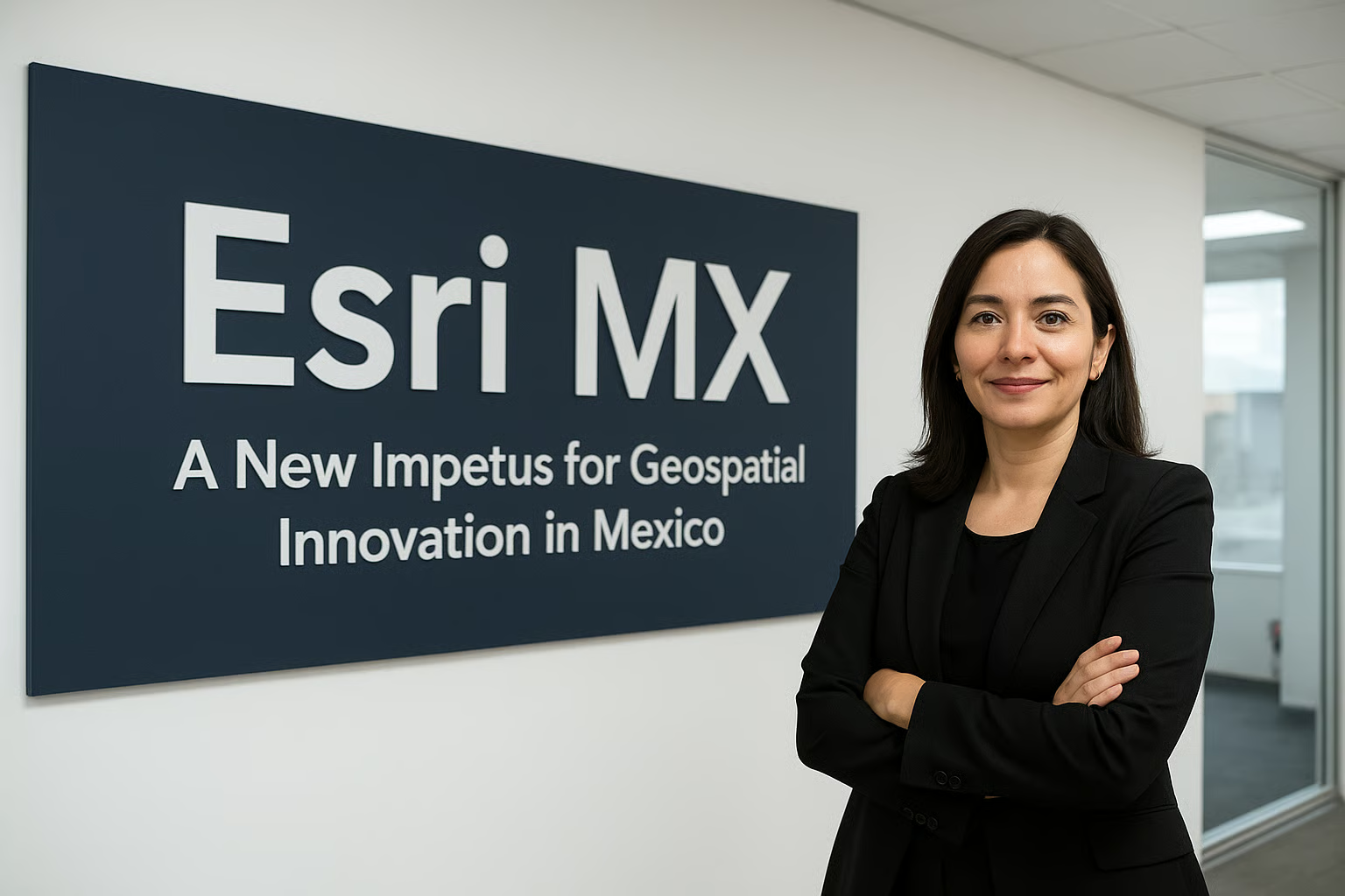 Image-R.E.News©
Le paysage de l’intelligence géospatiale au Mexique vient de franchir une étape historique. Esri, le leader mondial des systèmes d’information géographique (SIG) et de la location intelligence, a officiellement inauguré Esri Mexico (Esri MX), son nouveau centre d’innovation géospatiale dans le pays. Cette nouvelle structure reprend l’ensemble des activités jusqu’ici portées par son partenaire de longue date, SIGSA (Sistemas de Información Geográfica S.A.), qui a marqué l’histoire du secteur depuis plus de quatre décennies.
Cette transition symbolise plus qu’un simple changement de structure : elle incarne le passage vers une ère nouvelle, où l’innovation locale et les besoins spécifiques du Mexique sont placés au cœur des stratégies de développement.
Un héritage solide, un futur prometteur
Depuis sa création en 1980, SIGSA a accompagné l’évolution géospatiale du Mexique, en introduisant la photogrammétrie, en modernisant le cadastre et en déployant des solutions avancées de SIG dans des secteurs variés. Esri MX s’appuie sur cet héritage et entend aller encore plus loin : plus agile, plus proche du terrain, plus à même de relever les défis uniques du pays.
Jack Dangermond, président et fondateur d’Esri, a salué cette transition :
« SIGSA a été l’un de nos partenaires les plus fidèles et les plus visionnaires. Avec Esri MX, nous consolidons cet héritage et réaffirmons notre engagement à accompagner les communautés, les gouvernements et les organisations mexicaines avec des solutions innovantes et adaptées à leurs réalités. »
Un leadership local pour un impact global
À la tête de cette nouvelle aventure, Paola Salmán prend le rôle de PDG et actionnaire majoritaire d’Esri MX. Déjà reconnue pour avoir piloté avec succès les activités d’Esri au sein de SIGSA, elle apporte une vision ambitieuse et résolument tournée vers l’avenir.
« Ce lancement marque un nouveau chapitre, confie-t-elle. Nous honorons le passé, tout en embrassant le futur. Esri MX développera des solutions géospatiales locales, pensées pour répondre aux défis majeurs du pays : urbanisation rapide, résilience environnementale, sécurité publique, ou encore infrastructures durables. Fidèles aux valeurs d’Esri – science, service et durabilité – nous sommes prêts à continuer à cartographier l’avenir, ensemble. »
SIGSA, loin de disparaître, continuera de jouer un rôle clé en tant que partenaire stratégique, renforçant ainsi l’écosystème autour d’ArcGIS au Mexique.
Un hub d’innovation au service du pays
Avec Esri MX, le Mexique dispose désormais d’un véritable centre d’innovation géospatiale capable de conjuguer expertise mondiale et ancrage local. L’objectif est clair : mettre les données spatiales au service de la prise de décision, de l’efficacité opérationnelle et de la résilience face aux défis environnementaux.
Les secteurs bénéficiaires sont nombreux : gouvernements, services publics, transport, ressources naturelles, éducation et au-delà. Chaque solution sera adaptée aux contextes économiques, sociaux et culturels du pays, pour que l’innovation ne soit pas importée telle quelle, mais bien intégrée dans la réalité mexicaine.
Répondre aux défis uniques du Mexique
Le pays fait face à des enjeux multiples : urbanisation accélérée, pressions environnementales, infrastructures vieillissantes. Dans les mégapoles comme dans les zones rurales, les besoins sont pressants : mieux planifier les villes, surveiller les écosystèmes, renforcer la sécurité publique ou anticiper les catastrophes climatiques.
Grâce à la technologie SIG, ces défis peuvent être abordés de manière proactive : modélisation des réseaux de transport, optimisation des services publics, suivi en temps réel des écosystèmes, scénarios de prévention face aux risques naturels, ou encore planification d’infrastructures résilientes.
Esri MX ambitionne de devenir le catalyseur de ces transformations.
Un ancrage local, une portée mondiale
Esri, fondée en 1969 en Californie, est aujourd’hui implantée dans plus de 100 pays, soutenant des centaines de milliers d’organisations – entreprises, agences publiques, ONG, universités. Son approche géographique de la résolution de problèmes est devenue incontournable dans la planification moderne.
Avec Esri MX, cette expertise mondiale s’ancre désormais directement au Mexique, garantissant des solutions à la fois de pointe et localement pertinentes.
Une vision tournée vers la collaboration et la résilience
L’un des objectifs majeurs d’Esri MX sera de stimuler les collaborations entre acteurs mexicains et communauté géospatiale internationale. Cette dynamique favorisera l’échange de connaissances, la formation de talents et la co-création d’applications SIG adaptées.
Au cœur de cette mission : la résilience. Dans un contexte de changement climatique, les outils SIG permettent d’anticiper, de planifier et de protéger. Esri MX accompagnera ainsi la mise en place de modèles prédictifs, de systèmes de suivi en temps réel et de solutions participatives pour renforcer la préparation aux crises.
Cartographier l’avenir, ensemble
Avec le lancement d’Esri MX, le Mexique s’offre une nouvelle force motrice pour son avenir géospatial. Plus agile, plus proche des réalités locales et soutenu par l’expertise mondiale d’Esri, le pays dispose désormais d’un levier puissant pour transformer ses défis en opportunités.
Comme le résume Paola Salmán :
« Nous sommes prêts à continuer de cartographier l’avenir, ensemble. »
En plaçant l’innovation géospatiale au service du développement durable, Esri MX trace une voie claire : faire du Mexique un acteur de référence en matière de technologies SIG et un modèle d’intégration entre expertise locale et vision globale.
NJC.© Info SIGSA (Sistemas de Información Geográfica S.A.) Jack Dangermond, President and Founder of Esri
-------------------------------------------------------------------------------------------------------------------
03/10/25-English
Esri MX: A New Impetus for Geospatial Innovation in Mexico
Image-R.E.News©
The geospatial intelligence landscape in Mexico has reached a historic milestone. Esri, the global leader in geographic information systems (GIS) and location intelligence, has officially inaugurated Esri Mexico (Esri MX), its new geospatial innovation center in the country. This new structure incorporates all the activities previously carried out by its longtime partner, SIGSA (Sistemas de Información Geográfica S.A.), which has shaped the history of the sector for more than four decades.
This transition symbolizes more than just a structural change: it embodies the transition to a new era, where local innovation and the specific needs of Mexico are placed at the heart of development strategies.
A Solid Legacy, a Promising Future
Since its founding in 1980, SIGSA has supported Mexico's geospatial evolution, introducing photogrammetry, modernizing the land registry, and deploying advanced GIS solutions across a variety of sectors. Esri MX builds on this legacy and intends to go even further: more agile, closer to the field, and better able to address the country's unique challenges.
Jack Dangermond, President and Founder of Esri, welcomed this transition:
"SIGSA has been one of our most loyal and visionary partners. With Esri MX, we are building on this legacy and reaffirming our commitment to supporting Mexican communities, governments, and organizations with innovative solutions tailored to their realities."
Local Leadership for Global Impact
At the helm of this new venture, Paola Salmán takes on the role of CEO and majority shareholder of Esri MX. Already recognized for successfully leading Esri's activities within SIGSA, she brings an ambitious and resolutely forward-looking vision.
"This launch marks a new chapter," she says. "We honor the past while embracing the future. Esri MX will develop local geospatial solutions designed to address the country's major challenges: rapid urbanization, environmental resilience, public safety, and sustainable infrastructure. True to Esri's values—science, service, and sustainability—we are ready to continue mapping the future, together."
SIGSA, far from disappearing, will continue to play a key role as a strategic partner, strengthening the ArcGIS ecosystem in Mexico.
An innovation hub serving the country
With Esri MX, Mexico now has a true geospatial innovation center capable of combining global expertise with local roots. The objective is clear: to harness spatial data to support decision-making, operational efficiency, and resilience in the face of environmental challenges.
The beneficiary sectors are numerous: governments, public services, transportation, natural resources, education, and beyond. Each solution will be adapted to the country's economic, social, and cultural contexts, ensuring that innovation is not imported as is, but rather integrated into the Mexican reality.
Addressing Mexico's Unique Challenges
The country faces multiple challenges: accelerated urbanization, environmental pressures, and aging infrastructure. In both megacities and rural areas, the needs are pressing: better city planning, ecosystem monitoring, public safety, and climate-related disasters.
Thanks to GIS technology, these challenges can be addressed proactively: modeling transportation networks, optimizing public services, real-time monitoring of ecosystems, natural hazard prevention scenarios, and resilient infrastructure planning.
Esri MX aims to become the catalyst for these transformations.
Local roots, global reach
Esri, founded in 1969 in California, is now established in more than 100 countries, supporting hundreds of thousands of organizations—businesses, public agencies, NGOs, and universities. Its geographic approach to problem-solving has become essential in modern planning.
With Esri MX, this global expertise is now directly anchored in Mexico, ensuring solutions that are both cutting-edge and locally relevant.
A vision focused on collaboration and resilience
One of the major objectives of Esri MX will be to stimulate collaboration between Mexican stakeholders and the international geospatial community. This dynamic will foster knowledge exchange, talent training, and the co-creation of tailored GIS applications.
At the heart of this mission: resilience. In a changing climate, GIS tools enable us to anticipate, plan, and protect. Esri MX will support the implementation of predictive models, real-time monitoring systems, and participatory solutions to strengthen crisis preparedness.
Mapping the Future, Together
With the launch of Esri MX, Mexico has a new driving force for its geospatial future. More agile, closer to local realities, and supported by Esri's global expertise, the country now has a powerful lever to transform its challenges into opportunities.
As Paola Salmán summarizes:
"We are ready to continue mapping the future, together."
By placing geospatial innovation at the service of sustainable development, Esri MX charts a clear path: to make Mexico a leading player in GIS technologies and a model for integrating local expertise and global vision.
NJC.© Info SIGSA (Sistemas de Información Geográfica S.A.) Jack Dangermond, President and Founder of Esri
---------------------------------------------------------------------------------------------------------------
03/10/25-NL
Esri MX: Een nieuwe impuls voor geospatiale innovatie in Mexico
Image-R.E.News©
Het geospatiale intelligence-landschap in Mexico heeft een historische mijlpaal bereikt. Esri, wereldwijd leider in geografische informatiesystemen (GIS) en locatie-intelligentie, heeft officieel Esri Mexico (Esri MX) geopend, het nieuwe geospatiale innovatiecentrum in het land. Deze nieuwe structuur omvat alle activiteiten die voorheen werden uitgevoerd door haar jarenlange partner, SIGSA (Sistemas de Información Geográfica S.A.), die de geschiedenis van de sector al meer dan vier decennia vormgeeft.
Deze transitie symboliseert meer dan alleen een structurele verandering: het belichaamt de overgang naar een nieuw tijdperk, waarin lokale innovatie en de specifieke behoeften van Mexico centraal staan in ontwikkelingsstrategieën.
Een solide erfenis, een veelbelovende toekomst
Sinds de oprichting in 1980 ondersteunt SIGSA de geospatiale evolutie van Mexico door fotogrammetrie te introduceren, het kadaster te moderniseren en geavanceerde GIS-oplossingen in diverse sectoren te implementeren. Esri MX bouwt voort op deze erfenis en wil nog verder gaan: wendbaarder, dichter bij de praktijk en beter in staat om de unieke uitdagingen van het land aan te pakken.
Jack Dangermond, president en oprichter van Esri, verwelkomde deze overgang:
"SIGSA is een van onze meest loyale en visionaire partners. Met Esri MX bouwen we voort op deze erfenis en bevestigen we onze toewijding om Mexicaanse gemeenschappen, overheden en organisaties te ondersteunen met innovatieve oplossingen die zijn afgestemd op hun realiteit."
Lokaal leiderschap voor wereldwijde impact
Aan het roer van deze nieuwe onderneming neemt Paola Salmán de rol van CEO en meerderheidsaandeelhouder van Esri MX op zich. Ze staat al bekend om haar succesvolle leiding van Esri's activiteiten binnen SIGSA en brengt een ambitieuze en resoluut toekomstgerichte visie met zich mee.
"Deze lancering markeert een nieuw hoofdstuk", zegt ze. We eren het verleden en omarmen de toekomst. Esri MX zal lokale geospatiale oplossingen ontwikkelen die zijn ontworpen om de grootste uitdagingen van het land aan te pakken: snelle verstedelijking, milieubestendigheid, openbare veiligheid en duurzame infrastructuur. Trouw aan Esri's waarden – wetenschap, dienstverlening en duurzaamheid – zijn we klaar om samen de toekomst in kaart te blijven brengen.
SIGSA zal, verre van te verdwijnen, een belangrijke rol blijven spelen als strategische partner en het ArcGIS-ecosysteem in Mexico versterken.
Een innovatiecentrum ten dienste van het land
Met Esri MX beschikt Mexico nu over een echt geospatiaal innovatiecentrum dat wereldwijde expertise combineert met lokale wortels. Het doel is duidelijk: ruimtelijke data benutten ter ondersteuning van besluitvorming, operationele efficiëntie en veerkracht in het licht van milieu-uitdagingen.
De sectoren die hiervan profiteren zijn talrijk: overheden, openbare diensten, transport, natuurlijke hulpbronnen, onderwijs en meer. Elke oplossing zal worden aangepast aan de economische, sociale en culturele context van het land, zodat innovatie niet zomaar wordt geïmporteerd, maar juist wordt geïntegreerd in de Mexicaanse realiteit.
De unieke uitdagingen van Mexico aanpakken
Het land staat voor meerdere uitdagingen: versnelde verstedelijking, milieudruk en verouderde infrastructuur. Zowel in megasteden als op het platteland zijn de behoeften urgent: betere stadsplanning, ecosysteemmonitoring, openbare veiligheid en klimaatgerelateerde rampen.
Dankzij GIS-technologie kunnen deze uitdagingen proactief worden aangepakt: het modelleren van transportnetwerken, het optimaliseren van openbare diensten, realtime monitoring van ecosystemen, scenario's voor het voorkomen van natuurrampen en veerkrachtige infrastructuurplanning.
Esri MX wil de katalysator worden voor deze transformaties.
Lokale wortels, wereldwijd bereik
Esri, opgericht in 1969 in Californië, is nu gevestigd in meer dan 100 landen en ondersteunt honderdduizenden organisaties: bedrijven, overheidsinstanties, ngo's en universiteiten. De geografische benadering van probleemoplossing is essentieel geworden in moderne planning.
Met Esri MX is deze wereldwijde expertise nu direct verankerd in Mexico, wat zorgt voor oplossingen die zowel baanbrekend als lokaal relevant zijn.
Een visie gericht op samenwerking en veerkracht
Een van de belangrijkste doelstellingen van Esri MX is het stimuleren van de samenwerking tussen Mexicaanse stakeholders en de internationale geospatiale gemeenschap. Deze dynamiek zal kennisuitwisseling, talenttraining en de co-creatie van op maat gemaakte GIS-toepassingen bevorderen.
De kern van deze missie: veerkracht. In een veranderend klimaat stellen GIS-tools ons in staat te anticiperen, te plannen en te beschermen. Esri MX ondersteunt de implementatie van voorspellende modellen, realtime monitoringsystemen en participatieve oplossingen om de crisisparaatheid te versterken.
Samen de toekomst in kaart brengen
Met de lancering van Esri MX heeft Mexico een nieuwe drijvende kracht voor zijn geospatiale toekomst. Wendbaarder, dichter bij de lokale realiteit en ondersteund door Esri's wereldwijde expertise, beschikt het land nu over een krachtig instrument om zijn uitdagingen om te zetten in kansen.
Zoals Paola Salmán samenvat:
"We zijn klaar om samen de toekomst in kaart te brengen."
Door geospatiale innovatie ten dienste te stellen van duurzame ontwikkeling, stippelt Esri MX een duidelijke koers uit: van Mexico een toonaangevende speler maken in GIS-technologieën en een model voor de integratie van lokale expertise en wereldwijde visie.
NJC.© Info SIGSA (Sistemas de Información Geográfica S.A.) Jack Dangermond, President and Founder of Esri
---------------------------------------------------------------------------------------------------------------------
Date de dernière mise à jour : 02/10/2025