


R.E.News International-How New Caledonia’s Engineers Tamed a Landslide Without Rerouting
 04/08/25-FR-English-NL-footer
Comment les ingénieurs de Nouvelle-Calédonie ont maîtrisé un glissement de terrain sans dévier
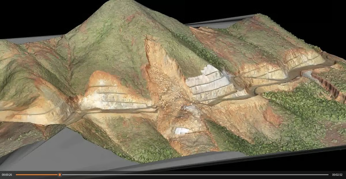 A detailed sequence of the landslide lifecycle, showcasing the progression from construction commencement, through slope failures, geotechnical investigations, model development, remedial design, and culminating in successful remediation works. Image by Seequent.
Le paysage spectaculaire de Nouvelle-Calédonie est tout simplement époustouflant : un mélange accidenté de relief montagneux, de pluies tropicales et d’écosystèmes dynamiques. Mais pour les ingénieurs chargés de construire des infrastructures routières essentielles sur un tel terrain, le paysage est moins parfait qu’un véritable champ de mines logistique et géologique. Pourtant, lorsqu’un glissement de terrain profond a menacé de faire dérailler un projet routier majeur, une combinaison astucieuse d’outils numériques, de collaboration à distance et de conception basée sur les données a sauvé la mise – et le budget.
Hatch, le cabinet d’ingénierie mondial au cœur de ce défi, gérait la construction d’une route d’accès vitale de 2,2 km traversant des collines abruptes. Entre les fortes pentes et la volatilité des sols tropicaux, le projet était déjà un exercice d’équilibre. Puis, en octobre 2021, Dame Nature a joué un rôle crucial.
En fin d'après-midi, après le pointage de l'équipe, environ 15 000 mètres cubes de terre et de roches ont commencé à se déplacer. Un glissement de terrain a balayé une section de 50 mètres de la route en construction. Heureusement, personne n'a été blessé, mais l'incident a immédiatement interrompu les travaux. Dix jours plus tard, un glissement secondaire a ajouté 10 000 mètres cubes supplémentaires au désordre.
Le hic ? Ce n'était même pas la section la plus raide ou la plus élevée de la route.
Avec le temps qui passe et les budgets serrés, deux solutions évidentes mais coûteuses se sont imposées : construire une route entièrement nouvelle autour du danger ou aplanir la pente existante à un angle plus sûr. L'une ou l'autre de ces solutions aurait grever le budget de 50 millions de dollars et repoussé les délais de plusieurs mois.
Plutôt que de paniquer ou de tout foncer, Hatch s'est tourné vers les outils géotechniques numériques de pointe de Seequent et Bentley Systems. Il ne s'agissait pas de simples logiciels de modélisation sophistiqués, mais devinrent l'épine dorsale de la stratégie de remédiation.
Simon Hope, ingénieur géotechnique principal chez Hatch, l'a clairement exprimé : « Le logiciel a permis de stabiliser le glissement de terrain et d'évaluer l'état de la pente afin de poursuivre le projet.»
Décomposons l'équipe numérique de rêve :
OpenGround : une plateforme cloud pour la collecte et la gestion des données géotechniques du site.
Leapfrog Works : utilisé pour développer des modèles géologiques 3D.
GeoStudio et PLAXIS : des outils performants pour l'analyse de la stabilité.
Au départ, l'équipe travaillait avec des coupes transversales 2D traditionnelles de la pente. Cela fonctionnait bien dans certaines zones. Mais dans d'autres ? Moins bien. Le tracé sinueux de la route et la variabilité des formations rocheuses rendaient impossible une vision d'ensemble. Leapfrog Works a changé la donne.
Hope a noté : « L'interpolation entre ces coupes [2D] était très difficile en raison de la géométrie sinueuse de la route et des conditions géologiques variables. Un modèle 3D Leapfrog a donc été adopté pour mieux modéliser et évaluer les conditions complexes du projet.» Construire une vue d'ensemble
En développant un modèle 3D complet avec Leapfrog, l'équipe a enfin pu voir ce qui se passait sous ses pieds. Ce modèle a signalé une zone de matériaux particulièrement fragiles à la base de la pente effondrée. Bingo ! C'était probablement le déclencheur de l'effondrement.
La compatibilité entre OpenGround, Leapfrog et GeoStudio a permis d'effectuer des mises à jour à la volée, au fur et à mesure de l'avancement des travaux. Et comme OpenGround était basé sur le cloud, les ingénieurs de Hatch à Brisbane, Perth, Calgary et sur l'île ont pu collaborer en temps quasi réel, même pendant les restrictions de déplacement liées à la pandémie.
Les avantages ne se sont pas limités à la poursuite du projet :
Les coûts de réparation des glissements de terrain ont été divisés par deux.
Le réalignement complet de la route a été évité, ce qui a permis de gagner du temps et de l'argent.
Les émissions de carbone ont été réduites de 17 000 tonnes, grâce à la réduction des travaux de terrassement et à la collaboration à distance.
Les forêts tropicales sensibles ont été préservées, prévenant ainsi les dommages écologiques et culturels dans une région politiquement complexe.
Les visuels parlent plus fort que les mots
Au-delà des chiffres, un autre avantage inattendu est apparu : la communication. Avec les principales parties prenantes, dont le vérificateur indépendant du projet, parlant français, et le jargon technique de l'ingénierie géotechnique en anglais, les discussions se heurtaient à la barrière de la langue.
La solution ? Laisser les visuels parler.
« Leapfrog a fait de la consolidation et de la visualisation des résultats de l'étude de site et des données géologiques et géotechniques un outil très puissant et essentiel pour la rapidité d'exécution et l'avancement de notre projet », a déclaré Hope.
« Le modèle était régulièrement présenté lors des réunions pour expliquer un concept ou présenter des données techniques. Comme on dit, une image vaut mille mots.»
Travailler plus intelligemment, pas plus dur
Face à l'imprévisibilité de la nature, l'équipe Hatch a réussi à éviter catastrophes et retards. En utilisant la technologie pour diagnostiquer le mécanisme de rupture de la pente et réévaluer les stratégies de construction en cours de route, elle a maintenu le projet routier en vie et sur la bonne voie.
Il ne s'agissait pas simplement de déplacer des pixels dans un modèle 3D. Il s'agissait d'utiliser des connaissances géotechniques avancées pour guider des décisions pratiques et concrètes. Et dans des endroits comme la Nouvelle-Calédonie, où chaque chargement de gravier et chaque excavation doit être évalué au regard de son empreinte écologique et culturelle, c'est important.
Ce qui est peut-être le plus impressionnant ici n'est pas seulement l'utilisation réussie du logiciel, mais aussi la façon dont il a permis à une équipe diversifiée, multilingue et répartie dans le monde entier de fonctionner comme une seule et même unité. Le partage de données en temps réel, la prise de décision collaborative et la visualisation intelligente ont fait toute la différence.
Cela laisse également entrevoir une tendance plus large dans le domaine des infrastructures : les jumeaux numériques, la collaboration cloud et la géovisualisation ne sont pas que des mots à la mode, mais des éléments vitaux.
Dans un monde où les exigences des terrains, de la météo et des parties prenantes sont de plus en plus complexes, l'avenir de la construction repose sur la modélisation intelligente, les données intelligentes et des équipes capables de s'adapter rapidement et de communiquer clairement. Le travail de Hatch en Nouvelle-Calédonie illustre parfaitement ces trois aspects.
Ouvrir la voie
Grâce à une approche avant-gardiste, Hatch a non seulement maintenu le projet routier sur la bonne voie, mais a également établi une nouvelle référence en matière d'approche des problèmes géotechniques complexes. C'est une leçon sur le pouvoir de la préparation, la force de la collaboration mondiale et l'importance croissante d'une intégration transparente de la technologie dans les processus de construction.
Ce projet nous rappelle que la réussite en ingénierie ne se résume pas toujours à la construction du plus grand pont ou de la plus haute tour. Parfois, il s'agit de comprendre le terrain, de s'adapter avec finesse et d'utiliser tous les outils à sa disposition pour garantir que les progrès ne se fassent pas au détriment des personnes, de la nature ou du budget.
NJC.© Info OpenGround
----------------------------------------------------------------------------------------------------------------
04/08/25-English
How New Caledonia’s Engineers Tamed a Landslide Without Rerouting
A detailed sequence of the landslide lifecycle, showcasing the progression from construction commencement, through slope failures, geotechnical investigations, model development, remedial design, and culminating in successful remediation works. Image by Seequent.
New Caledonia’s dramatic landscape is nothing short of breath-taking – a rugged blend of mountainous terrain, tropical downpours, and vibrant ecosystems. But for engineers tasked with building critical road infrastructure through such terrain, it’s less postcard-perfect and more of a logistical and geological minefield. Still, when a deep-seated landslide threatened to derail a major road project, a clever blend of digital tools, remote collaboration, and data-driven design saved the day – and the budget.
Hatch, the global engineering firm at the heart of this challenge, was managing the construction of a vital 2.2km access road slicing through steep hillsides. With high-cut slopes and volatile tropical soils in play, the project was already a juggling act. Then, in October 2021, Mother Nature threw a curveball.
Late one afternoon, after the crew had clocked out, roughly 15,000 cubic metres of soil and rock decided to shift. A landslide swept across a 50-metre section of the road under construction. Fortunately, no one was hurt, but the incident halted work instantly. Within ten days, a secondary slide added another 10,000 cubic metres to the mess.
The kicker ? This wasn’t even the steepest or highest section of the road.
With the clock ticking and budgets on edge, two obvious but costly solutions surfaced: build an entirely new road around the hazard or flatten the existing slope at a safer angle. Either choice would have strained the $50 million budget and pushed timelines back by months.
Rather than panic or bulldoze ahead, Hatch turned to cutting-edge digital geotechnical tools from Seequent and Bentley Systems. These weren’t just fancy modelling programs – they became the backbone of the remediation strategy.
Simon Hope, principal geotechnical engineer at Hatch, put it plainly: “The software allowed for the landslide to be stabilised and slope conditions assessed so that the project could continue.”
Let’s break down the digital dream team:
OpenGround: A cloud-based platform for collecting and managing geotechnical site data.
Leapfrog Works: Used to develop 3D geological models.
GeoStudio and PLAXIS: Heavy-hitters for stability analysis.
Initially, the team worked with traditional 2D cross-sections of the slope. That worked fine in some areas. But in others? Not so much. The road’s meandering path and variable rock formations made it impossible to grasp the bigger picture. Leapfrog Works changed that.
Hope noted: “Trying to interpolate between these [2D] sections was very difficult due to the meandering road geometry and variable geological conditions. A 3D Leapfrog model was therefore adopted to best model and assess the complex project conditions.”
Building the Bigger Picture
By developing a full 3D model using Leapfrog, the team could finally see what was happening beneath their boots. That model flagged a zone of particularly weak material at the base of the failed slope. Bingo – that was likely the trigger for the collapse above.
The compatibility between OpenGround, Leapfrog, and GeoStudio meant that updates could be made on the fly as construction progressed. And because OpenGround was cloud-based, Hatch engineers in Brisbane, Perth, Calgary and on the island could collaborate in near real-time, even during pandemic travel restrictions.
The perks didn’t stop at project continuation:
Landslide remediation costs were halved.
The need for a complete road realignment was avoided, saving time and cash.
Carbon emissions were cut by 17,000 tonnes, thanks to reduced earthworks and remote collaboration.
Sensitive rainforests were preserved, preventing ecological and cultural damage in a politically complex region.
Visuals Speak Louder Than Words
Beyond the numbers, there was another unexpected benefit: communication. With key stakeholders, including the project’s independent verifier, speaking French, and the technical jargon of geotechnical engineering in English, discussions were hitting language barriers.
The solution? Let the visuals do the talking.
“Leapfrog made the consolidation and visualisation of the site survey results and geological and geotechnical data a very powerful and important tool in the quick turnaround and progress of our project,” said Hope.
“The model was routinely presented in meetings to explain a concept or present technical data. As they say, a picture speaks a thousand words.”
Working Smarter, Not Harder
Faced with nature’s unpredictability, the Hatch team managed to dodge both disaster and delay. By using technology to diagnose the slope’s failure mechanism and reassess construction strategies on the go, they kept the road project alive and on track.
This wasn’t just about pushing pixels around in a 3D model. It was about using advanced geotechnical insight to guide practical, boots-on-the-ground decisions. And in places like New Caledonia, where every truckload of gravel and every dig must be weighed against its ecological and cultural footprint, that matters.
What’s perhaps most impressive here isn’t just the successful use of software, but how it allowed a diverse, multilingual, and globally distributed team to function like a single, cohesive unit. Real-time data sharing, collaborative decision-making, and smart visualisation made all the difference.
It also hints at a wider trend in infrastructure: where digital twins, cloud collaboration, and geo-visualisation aren’t just buzzwords – they’re lifelines.
In a world of increasingly complex terrain, weather, and stakeholder demands, the future of construction lies in intelligent modelling, smart data, and teams that can adapt swiftly and communicate clearly. Hatch’s work in New Caledonia is a shining example of all three.
Paving the Way Forward
Thanks to a forward-thinking approach, Hatch not only kept the road project on track, but also set a new benchmark for how to approach complex geotechnical problems. It’s a lesson in the power of preparedness, the strength of global collaboration, and the growing importance of integrating technology seamlessly into construction workflows.
This project reminds us that engineering success isn’t always about building the biggest bridge or the tallest tower. Sometimes, it’s about reading the land, adapting with finesse, and using every tool at your disposal to ensure progress doesn’t come at the cost of people, nature, or budget.
NJC.© Info OpenGround
----------------------------------------------------------------------------------------------------------------
04/08/25-NL
Hoe ingenieurs in Nieuw-Caledonië een aardverschuiving temden zonder omleiding
A detailed sequence of the landslide lifecycle, showcasing the progression from construction commencement, through slope failures, geotechnical investigations, model development, remedial design, and culminating in successful remediation works. Image by Seequent.
Het dramatische landschap van Nieuw-Caledonië is ronduit adembenemend – een ruige mix van bergachtig terrein, tropische stortbuien en levendige ecosystemen. Maar voor ingenieurs die belast zijn met de aanleg van kritieke wegeninfrastructuur in dit gebied, is het minder perfect voor een ansichtkaart en meer een logistiek en geologisch mijnenveld. Toch, toen een diepe aardverschuiving een groot wegenproject dreigde te verstoren, redde een slimme combinatie van digitale tools, samenwerking op afstand en datagestuurd ontwerp de dag – en het budget.
Hatch, het wereldwijde ingenieursbureau dat centraal stond in deze uitdaging, beheerde de aanleg van een cruciale 2,2 km lange toegangsweg die zich door steile hellingen slingerde. Met steile hellingen en onstabiele tropische bodems was het project al een lastige opgave. Tot Moeder Natuur in oktober 2021 voor een verrassing zorgde.
Op een late namiddag, nadat de ploeg klaar was met werken, begon ongeveer 15.000 kubieke meter grond en gesteente te verschuiven. Een aardverschuiving overspoelde een stuk van 50 meter van de weg in aanbouw. Gelukkig raakte niemand gewond, maar het incident legde de werkzaamheden direct stil. Binnen tien dagen voegde een tweede aardverschuiving nog eens 10.000 kubieke meter toe aan de puinhoop.
De klap? Dit was niet eens het steilste of hoogste deel van de weg.
Met de klok die tikte en de budgetten die gespannen stonden, kwamen twee voor de hand liggende maar kostbare oplossingen naar voren: een geheel nieuwe weg aanleggen rond het gevaar of de bestaande helling afvlakken in een veiligere hoek. Beide opties zouden het budget van $ 50 miljoen onder druk hebben gezet en de planning met maanden hebben vertraagd.
In plaats van in paniek te raken of door te ploeteren, schakelde Hatch over op geavanceerde digitale geotechnische tools van Seequent en Bentley Systems. Dit waren niet zomaar geavanceerde modelleringsprogramma's – ze vormden de ruggengraat van de saneringsstrategie.
Simon Hope, hoofd geotechniek bij Hatch, verwoordde het kort en bondig: "De software maakte het mogelijk om de aardverschuiving te stabiliseren en de hellingcondities te beoordelen, zodat het project kon worden voortgezet."
Laten we het digitale dreamteam eens nader bekijken:
OpenGround: Een cloudgebaseerd platform voor het verzamelen en beheren van geotechnische locatiegegevens.
Leapfrog Works: Gebruikt voor de ontwikkeling van 3D-geologische modellen.
GeoStudio en PLAXIS: Krachtpatsers voor stabiliteitsanalyse.
Aanvankelijk werkte het team met traditionele 2D-dwarsdoorsneden van de helling. Dat werkte op sommige plekken prima. Maar op andere? Niet zo goed. Het kronkelende pad van de weg en de variabele rotsformaties maakten het onmogelijk om het grotere geheel te overzien. Leapfrog Works bracht daar verandering in.
Hope merkte op: "Het interpoleren tussen deze [2D] secties was erg lastig vanwege de kronkelende weggeometrie en de variabele geologische omstandigheden. Daarom werd een 3D Leapfrog-model gebruikt om de complexe projectomstandigheden zo goed mogelijk te modelleren en te beoordelen." Het grotere plaatje schetsen
Door een volledig 3D-model te ontwikkelen met Leapfrog kon het team eindelijk zien wat er onder hun schoenen gebeurde. Dat model markeerde een zone met bijzonder zwak materiaal aan de voet van de ingestorte helling. Bingo – dat was waarschijnlijk de aanleiding voor de instorting erboven.
De compatibiliteit tussen OpenGround, Leapfrog en GeoStudio betekende dat updates direct konden worden doorgevoerd naarmate de bouw vorderde. En omdat OpenGround cloudgebaseerd was, konden Hatch-ingenieurs in Brisbane, Perth, Calgary en op het eiland bijna realtime samenwerken, zelfs tijdens de reisbeperkingen vanwege de pandemie.
De voordelen stopten niet bij de voortzetting van het project:
De kosten voor het herstel van de aardverschuiving werden gehalveerd.
De noodzaak voor een volledige herinrichting van de weg werd vermeden, wat tijd en geld bespaarde.
De CO2-uitstoot werd met 17.000 ton verminderd dankzij minder grondwerk en samenwerking op afstand.
Kwetsbare regenwouden werden behouden, waardoor ecologische en culturele schade in een politiek complexe regio werd voorkomen.
Visuele aspecten spreken meer dan woorden
Naast de cijfers was er nog een onverwacht voordeel: communicatie. Doordat belangrijke stakeholders, waaronder de onafhankelijke verificateur van het project, Frans spraken en geotechnisch jargon Engels was, liepen de discussies op taalbarrières.
De oplossing? Laat de visuele aspecten spreken.
"Leapfrog maakte van de consolidatie en visualisatie van de resultaten van het locatieonderzoek en de geologische en geotechnische gegevens een zeer krachtig en belangrijk hulpmiddel voor de snelle doorlooptijd en voortgang van ons project", aldus Hope.
"Het model werd routinematig gepresenteerd tijdens vergaderingen om een concept uit te leggen of technische gegevens te presenteren. Zoals ze zeggen: een beeld zegt meer dan duizend woorden."
Slimmer werken, niet harder
Geconfronteerd met de onvoorspelbaarheid van de natuur, wist het Hatch-team zowel een ramp als vertraging te voorkomen. Door technologie te gebruiken om het faalmechanisme van de helling te diagnosticeren en bouwstrategieën ter plekke te herzien, hielden ze het wegenproject draaiende en op schema.
Het ging niet alleen om het verschuiven van pixels in een 3D-model. Het ging erom geavanceerde geotechnische inzichten te gebruiken om praktische, praktische beslissingen te nemen. En in gebieden zoals Nieuw-Caledonië, waar elke vrachtwagen grind en elke opgraving moet worden afgewogen tegen de ecologische en culturele voetafdruk, is dat van belang.
Wat hier misschien wel het meest indrukwekkend is, is niet alleen het succesvolle gebruik van software, maar ook hoe het een divers, meertalig en wereldwijd verspreid team in staat stelde te functioneren als één samenhangende eenheid. Realtime data-uitwisseling, gezamenlijke besluitvorming en slimme visualisatie maakten het verschil.
Het wijst ook op een bredere trend in de infrastructuur: waar digitale tweelingen, samenwerking in de cloud en geovisualisatie niet alleen modewoorden zijn, maar levensaders.
In een wereld met steeds complexere terreinen, weersomstandigheden en steeds complexere eisen van belanghebbenden, ligt de toekomst van de bouw in intelligente modellering, slimme data en teams die zich snel kunnen aanpassen en helder kunnen communiceren. Hatchs werk in Nieuw-Caledonië is een schitterend voorbeeld van alle drie.
De weg vrijmaken
Dankzij een vooruitstrevende aanpak hield Hatch niet alleen het wegenproject op schema, maar zette hij ook een nieuwe standaard voor de aanpak van complexe geotechnische problemen. Het is een les in de kracht van voorbereiding, de kracht van wereldwijde samenwerking en het toenemende belang van de naadloze integratie van technologie in bouwprocessen.
Dit project herinnert ons eraan dat technisch succes niet altijd draait om het bouwen van de grootste brug of de hoogste toren. Soms gaat het om het interpreteren van de omgeving, je finesse eigen maken en alle beschikbare middelen gebruiken om ervoor te zorgen dat vooruitgang niet ten koste gaat van mensen, de natuur of het budget.
NJC.© Info OpenGround
------------------------------------------------------------------------------------------------------------------
Date de dernière mise à jour : 01/08/2025